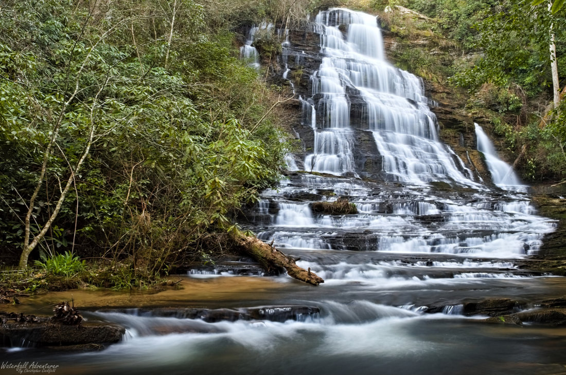
Sid's Falls
- Height: 100 feet
- Type: Cascading free-fall
- Stream: Shoulder Bone Branch
- River Basin: Savannah River
- Elevation: 1,390 feet
- Landowner: United States Department of Agriculture
- Recreational Area: Sumter National Forest, Andrew Pickens Ranger District
- State: South Carolina
- County: Oconee
- USGS Map: Rainy Mountain
- Difficulty: Strenuous
- Accessibility: Forest road, trail & scramble
- Trail Blaze: None
- Admission Fee: None
- Hike Length: 3 miles
- Waterfall GPS: 34.75577 -83.30779
- Parking GPS: 34.74179 -83.29893
Overview
Sid's Falls is named after waterfall extraordinaire Sidney Holmes Ballenger, Jr. (February 6, 1918 - November 9, 1991). Sidney and his two close friends John Danner and Maxie Duke self-published the first known waterfall book of Oconee County waterfalls in September 24, 1983, entitled Some Waterfalls, Shoals, and Cascades of Oconee County, South Carolina. Nine books were produced in total, three of which were kept for themselves and six were presented to the Oconee County Library in Walhalla, The State Library in Columbia, the County Planning and Development Commission, Walhalla High School, Walhalla Middle School and the Stumphouse Ranger Station (Sumter National Forest, Andrew Pickens Ranger District).
Driving Directions
From Westminster, South Carolina. From the intersection of US-123, head north on US-76 for 12.9 miles and turn left onto Damascus Church Road. Drive 0.8 miles and turn right onto Battlecreek Road. Drive 3 miles and turn right onto Damascus Church Road. Drive 0.8 miles and turn right onto the gated FS 2616 (Opossum Creek Road.) Do not block!
From Clayton, Georgia. From the intersection of US-441, head east on US-76 for 10.7 miles and turn right onto Orchard Road. Drive 2.4 miles and turn right onto Battlecreek Road. Drive 2.6 miles and turn right onto Damascus Church Road. Drive 0.8 miles and turn right onto the gated FS 2616 (Opossum Creek Road.) Do not block!
From Clayton, Georgia. From the intersection of US-441, head east on US-76 for 10.7 miles and turn right onto Orchard Road. Drive 2.4 miles and turn right onto Battlecreek Road. Drive 2.6 miles and turn right onto Damascus Church Road. Drive 0.8 miles and turn right onto the gated FS 2616 (Opossum Creek Road.) Do not block!
Hiking Directions
From the parking. Head around the gate and follow the road to a fork and keep right. Continue down the road for 500+ feet to the first of four wildlife clearings. Continue for 0.20 miles to a fork and head right, heading around the second clearing. Continue following the road for 0.64 miles to the third opening on the right. Follow the road for 0.23 miles to the forth and last wildlife clearing and head to the western side of the clearing to a trail (Was flagged 3/27/2018.) Follow the trail for 1,200+ feet to the waterfall, the last bit of the trail is pretty steep.
