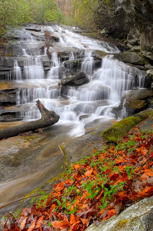
Rachael Creek Falls
- Height: 68 feet
- Type: Multi-level cascade
- Stream: Rachael Creek
- River Basin: Santee River
- Elevation: 1,222 feet
- Landowner: South Carolina Department of Natural Resources
- Recreational Area: Jocassee Gorges Wildlife Management Area
- State: South Carolina
- County: Pickens
- USGS Map: Table Rock
- Difficulty: Strenuous
- Accessibility: Forest road, trail and bushwhack
- Trail Blaze: Orange for the Palmetto Trail
- Admission Fee: None
- Hike Length: 3 miles
- Waterfall GPS: 35.01322 -82.73589
- Parking GPS: 35.00324 -82.74015
Overview
Rachael Creek Falls has an incredible rock wall on its left-side that towers over the middle section of the waterfall.
Driving Directions
From Pickens, South Carolina. From the intersection of SC-183, head northwest on US-178 for 8.6 miles and turn right onto SC-11. Drive 1.4 miles and park on the side of the road, near Alewine Road, which will be on the left-side of the road.
From Travelers Rest, South Carolina. From city center, head northwest on US-276 for 5.3 miles and turn left onto Pumpkintown Road (SC-288). Drive 12.3 miles and turn right onto Hickory Hollow Road. Drive 1.2 miles and turn left onto SC-11. Drive 1.6 miles and park on the side of the road, near Alewine Road, which will be on the right-side of the road.
From Rosman, North Carolina. From city center, head southwest on US-178 for 16.5 miles and turn left onto SC-11. Drive 1.4 miles and park on the side of the road, near Alewine Road, which will be on the left-side of the road.
Hiking Directions
From the parking. Head north up Alewine Road towards a red gate and follow the road for 0.27 miles to the first creek crossing and then another 450+ feet to a second creek crossing. Once across continue following the road for 0.46 miles to the Palmetto Trail and head right. Follow the Palmetto Trail for 0.44 miles to a small creek that goes under the trail and continue on the trail for 50 feet or so and head right. (You can also just follow the creek downstream if you don't wanna risk getting lost.)
Bushwhack south, southeast through the open woods for 570+ feet to Grotto Falls and carefully proceed downstream towards the top of Yucca Falls. Head east, going away from the creek to follow the steep hillside down to the base of the main drop of Yucca Falls. (Do be very careful here as a fall will severely hurt or kill you!) Continue downstream on the left-side of the creek a short ways to get below Lower Yucca Falls and cross the creek. Head up the hillside and follow it south for 300+ feet and then carefully drop down to Rachael Creek and make your way back upstream to the Rachael Creek Falls.
My GPS track can be found below. Click on the track name to be taken to the Gaia GPS website where you can save the track to your phone or computer.
